"Some of us will die": Hurricane Matthew bearing down on Haiti, Jamaica
Last Updated Oct 3, 2016 2:41 PM EDT
PORT-AU-PRINCE, Haiti - Vulnerable Haiti braced for flash floods, violent winds, and widespread destruction from the extremely dangerous Hurricane Matthew as the powerful storm approached the hemisphere’s poorest country Monday.
Heavy rains from the outer bands of the storm have already begun drenching Jamaica and Haiti on Monday, flooding streets and sending many people to emergency shelters as the Category 4 storm approached the two countries. Two deaths were reported in Haiti, bringing the total for the storm to at least four.
Matthew had sustained winds of 140 mph as it moved north, up from 130 mph earlier in the day. The center was expected to pass just east of Jamaica and near or over the southwestern tip of Haiti early Tuesday before heading to eastern Cuba, the U.S. National Hurricane Center in Miami said.
Matthew had sustained winds of 140 mph as it moved north, up from 130 mph earlier in the day. The center was expected to pass just east of Jamaica and near or over the southwestern tip of Haiti early Tuesday before heading to eastern Cuba, the U.S. National Hurricane Center in Miami said.
As of 2 p.m. EDT, the storm was centered about 250 miles southwest of Haiti’s capital of Port-au-Prince and 195 miles southeast of Kingston. It was moving north at 6 mph.
The director of Haiti’s Civil Protection Agency said two fishermen have died in rough water churned up by the approaching storm, hours before it was expected to make landfall. The government banned boating along the country’s coastlines starting Saturday. But the head of an 80-member fishermen’s association in the south coast town of Gressier says some fishermen were taking to the seas early Monday.
Johnny Souffrant says, “They feel they have to take risks to support their families.”
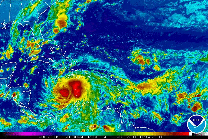
An animated GIF showing the cloud cover and rainfall in the Caribbean on the morning of October 3, 2016.
NOAA
The strongest part of a hurricane is usually the northeastern quadrant, which is likely to pass right over the fragile island nation. The storm was also predicted to hit the lightly populated eastern tip of Cuba on Tuesday afternoon.
Forecasters said as much as 40 inches of rain could fall on some isolated areas of Haiti, raising fears of deadly mudslides and floods in the heavily deforested country where many families live in flimsy houses with corrugated metal roofs.
“Some of us will die but I pray it won’t be a lot,” said Serge Barionette in the southern town of Gressier, where a river recurrently bursts its banks during serious storms.
The U.S. State Department warned American citizens to leave both Haiti and the Bahamas in advance of the storm.
A hurricane warning was in effect for Haiti, Jamaica and parts of Cuba. Rain was already lashing parts of Jamaica and flooding streets and homes, but forecasters said the southern Haitian countryside around Jeremie and Les Cayes could see the worst of the rains and punishing winds.
“Wherever that center passes close to would see the worst winds and that’s what’s projected to happen for the western tip of Haiti,” said John Cangilosi, a hurricane specialist at the U.S. center. “There is a big concern for rains there and also a big concern for storm surge.”
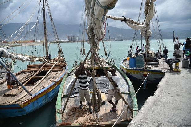
A man works on his boat in the Cite Soleil area of Port au Prince, Haiti on October 2, 2016.
HECTOR RETAMAL/AFP/GETTY IMAGES
Matthew is one of the most powerful Atlantic hurricanes in recent history and briefly reached the top classification, Category 5, becoming the strongest hurricane in the region since Felix in 2007. The hurricane center said the storm appeared to be on track to pass east of Florida through the Bahamas, but it was too soon to predict with certainty whether it would threaten any spot on the U.S. East Coast.
Regardless, it’s northward turn has prompted some officials on the U.S. East Coast to start making preparations.
In a news release issued Sunday, the South Carolina Emergency Management Division recommended that the state’s emergency response team review plans. Officials Horry, Beaufort and Charleston counties say they’re on alert status.
Division Director Kim Stenson held conference calls this weekend with county emergency managers, emergency response team agencies and local National Weather Service offices. Stenson says the storm’s path is too uncertain to rule out any possibility.
Division Director Kim Stenson held conference calls this weekend with county emergency managers, emergency response team agencies and local National Weather Service offices. Stenson says the storm’s path is too uncertain to rule out any possibility.
Officials with Haiti’s civil protection agency said there were roughly 1,300 emergency shelters across the country, enough to hold up to 340,000 people. Authorities broadcast warnings over the radio telling people to swiftly heed evacuation warnings, trying to counter a common tendency for people to try to stay in their homes to protect them during natural disasters.
In a brief address carried on state radio, interim President Jocelerme Privert urged Haitians to listen closely to official warnings and be ready to move. “To those people living in houses that could collapse, it’s necessary that you leave these houses to take refuge in schools and churches,” he said.
Teams of civil protection officials walked the streets of Les Cayes and other areas urging residents to secure their homes, prepare emergency kits and warn their neighbors. They also evacuated people from some outlying islands.

A hurricane warning was posted for the southeastern Bahamas. A hurricane watch was in effect for the Cuban province of Camaguey, the central Bahamas and the Turks and Caico Islands, and a tropical storm warning was issued for parts of the Dominican Republic, where authorities began mandatory evacuations of areas at risk for flooding. A tropical storm watch was in effect for parts of the Dominican Republic.
The hurricane earlier had been projected to be closer to Jamaica, but still was a danger to the island of less than 3 million inhabitants.
“The center of the system is looking more likely that it will pass to the east of Jamaica but it won’t miss it by that much, so they are still going to see impacts,” Cangilosi said. “The impacts are maybe going to be a little lower there than they would be in Haiti and eastern Cuba.”
After passing Jamaica and Haiti, Matthew was projected to reach Cuba. The storm center was expected to pass about 50 miles east of the U.S. Navy base at Guantanamo Bay, where authorities evacuated about 700 spouses and children of service members on military transport planes to Florida.
The U.S. installation has a population of about 5,500, including 61 men held at the detention center for terrorism suspects. Navy Capt. David Culpepper, the base commander, said emergency shelters had been set up and authorities were bracing for 80 mph winds along with storm surge and heavy rain that could threaten some low-lying areas, including around the power plant and water desalination facility.
“We have no choice but to prepare ourselves to take a frontal assault if you will,” Culpepper said.
© 2016 CBS Interactive Inc. All Rights Reserved. This material may not be published, broadcast, rewritten, or redistributed. The Associated Press contributed to this report.
SHOW 10 COMMENTS +
Featured in World

Putin suspends plutonium disposal deal with U.S.
The state-run Tass News Agency reports the agreement was suspended because of “unfriendly” acts by Washington
"I had to:" Man explains "honor" killing sister
Tasleem was 18, a good Muslim girl, but to her family, being seen with a Christian man in a Lahore slum was too much